Old Maps of Ngarchelong
Explore 4 old maps of Ngarchelong, spanning from 1983 to today. These high-resolution historic maps reveal how streets, neighborhoods, landmarks, and natural features evolved over time — perfect for genealogy, metal detecting, research, and local history exploration.
What you can do with these maps:
- See how Ngarchelong changed over time: Compare historical maps to modern-day views to trace roads, homesites, rail lines & more.
- View detailed metadata: Each map includes creators, publishers, year, scale, and archive source.
- Overlay maps with satellite & LiDAR: Visualize the past alongside modern tools to explore terrain & human change.
- Trusted historical sources: Maps sourced from the USGS, Library of Congress, and other archives.
- Access maps your way: View online, download high-res files, or order prints for personal or research use.
Start exploring old maps of Ngarchelong to uncover forgotten places, hidden landmarks, and the deep history beneath your feet.
Ngarchelong maps
(4)- 1983 Map of Ngermetengel, 1984 Print
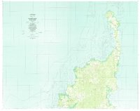 1983 Ngermetengel1984 Print · USGSBabeldaob's northern villages and complex coral reefs are mapped here in the early eighties. Researchers can trace traditional settlements from Ngermetengel up to Ollei, and locate inland features like the Mine near the western coast.
 - 1984 Map of Ngcheangel
 1984 Ngcheangel1984 Print · USGSNgcheangel atoll in the mid-1980s reveals a traditional Pacific settlement pattern structured around its reefs and lagoons. Researchers can locate coastal villages such as Dilong and Ngerlunga or trace the navigational channels of Toachel Ngerchelong.
 - 2000 Map of Babeldaob North, 2004 Print
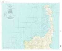 2000 Babeldaob North2004 Print · USGSNorthern Babeldaob Island at the start of the century reveals a coastal landscape of coral reefs and ridge-top villages. Researchers can locate community landmarks like Bethany church or trace the shoreline from Bkul a Ngesang to Ollei.
 - 2001 Map of Kayangel South, 2004 Print
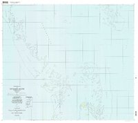 2001 Kayangel South2004 Print · USGSNorthern Palau waters and reef systems are captured here as they appeared at the turn of the millennium. Nautical researchers and historians can trace the coral reefs of Ngebard and locate island landmarks like Ngerechur and the Ruins at its center.
End of results
Showing maps 1-4 of 4
Frequently asked questions
- What are the different types of historical maps available for Ngarchelong?
- What is the oldest map of Ngarchelong?
- Where can I purchase historical maps of Ngarchelong for my home or office?
- Where can I download high-res historical maps of Ngarchelong?
- Are there historical topographic maps available for Ngarchelong?
- Is there historical aerial imagery available for Ngarchelong?
- Where are historical maps of Ngarchelong sourced from?