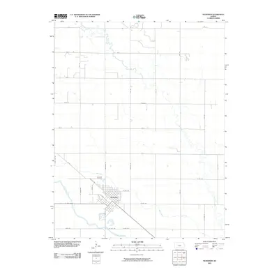
2009 Map of Nickerson
USGS Topo · Published 2009About this map
Nickerson serves as the focal point of this Kansas landscape, situated near the north bank of the Arkansas River. The town's grid is oriented diagonally, paralleling the path of Railroad Rd and RR St, reflecting the influence of the rail corridor on the settlement's early geometry. To the northwest, Wildmead Cemetery stands as a local landmark for genealogical research. The surrounding countryside is defined by the winding paths of Cow Creek and Bull Creek, which traverse the prairie and intersect a strictly maintained section-line road network that includes N Nickerson Rd and Riverton Rd. This 2009 survey by the U.S. Geological Survey documents the town's footprint as it was at the close of the decade, showing the proximity of the local watercourses like Dry Creek to the outlying residential and agricultural tracts.
Find a feature on this map
34 named features on this map. Tap any name to fly to it.
Don’t see what you’re looking for? This feature index may not catch every label — zoom into the map to look around manually.
Map Details
Editions of this 2009 Nickerson Map
This is the sole edition of this map. No revisions or reprints were ever made.
Other maps of this area

1891 · Hutchinson
USGS Topo · 1:125,000

1893 · Hutchinson
USGS Topo · 1:125,000

1894 · Lyons
USGS Topo · 1:125,000

1955 · Great Bend
USGS Topo · 1:250,000

1955 · Hutchinson
USGS Topo · 1:250,000

1957 · Great Bend
USGS Topo · 1:250,000

1958 · Great Bend
USGS Topo · 1:250,000

1959 · Hutchinson
USGS Topo · 1:250,000

1960 · Yaggy
USGS Topo · 1:24,000
1960 · Hutchinson
USGS Topo · 1:24,000