2023 Map of Nile
USGS Topo · Published 2023About this map
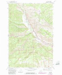
Nile Valley and the settlement of Nile occupy the heart of this landscape, situated along the corridor created by the Naches River. The terrain is characterized by a complex network of high ridges and deep canyons, with Bethel Ridge dominating the southern half and Cleman Mountain rising to the northeast. Much of the area is contained within the Snoqualmie National Forest, where resource management and recreation are primary land uses, as evidenced by naming conventions for seasonal locations like Sanford Pasture and the high-elevation point of Grouse Heaven.
Find a feature on this map
46 named features on this map. Tap any name to fly to it.
Don’t see what you’re looking for? This feature index may not catch every label — zoom into the map to look around manually.
Map Details
Editions of this 2023 Nile Map
This is the sole edition of this map. No revisions or reprints were ever made.