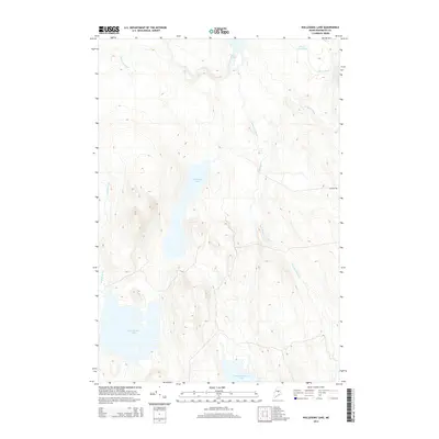
2014 Map of Nollesemic Lake
USGS Topo · Published 2014About this map
Nollesemic Lake sits at the heart of this Maine wilderness, north of the Penobscot River in a landscape defined by an intricate network of drainage and wetlands. This 2014 U.S. Geological Survey representation documents the hydrography of the region, from the expansive East Branch Lake and Mattamiscontis Lake in the south to Shad Pond at the northern edge. The presence of Miner Brook Bog and numerous feeders like Trapper Brook and Comstock Brook illustrates the low-lying, water-saturated terrain typical of the North Woods. Human intervention is sparse, represented by Jr Mack Rd and the identified Grand Falls, suggesting a region primarily utilized for timber or recreation rather than permanent settlement. The map serves as a detailed guide to the distinct watersheds formed by Nollesemic Stream and Sam Ayers Stream as they flow through this unpopulated portion of Penobscot County.
Find a feature on this map
14 named features on this map. Tap any name to fly to it.
Don’t see what you’re looking for? This feature index may not catch every label — zoom into the map to look around manually.
Map Details
Editions of this 2014 Nollesemic Lake Map
This is the sole edition of this map. No revisions or reprints were ever made.
Other maps of this area

1942 · Lincoln
USGS Topo · 1:62,500

1947 · Schoodic
USGS Topo · 1:62,500

1949 · Schoodic
USGS Topo · 1:62,500

1951 · Norcross
USGS Topo · 1:62,500

1951 · Millinocket
USGS Topo · 1:62,500

1954 · Millinocket
USGS Topo · 1:250,000

1957 · Lincoln
USGS Topo · 1:62,500

1958 · Millinocket
USGS Topo · 1:250,000

1960 · Millinocket
USGS Topo · 1:250,000

1975 · Millinocket SW
USGS Topo · 1:24,000
Featured Places
- Millinocket, ME
- T3 Indian Purchase Township, ME
- Hopkins Academy Grant Township, ME
- TA R7 WELS, ME
- Long A Township, ME