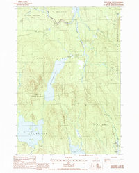
1988 Map of Nollesemic Lake
USGS Topo · Published 1988About this map
Nollesemic Lake sits at the heart of this North Woods landscape, dominated by complex water systems and township divisions in central Maine. The West Branch Penobscot River cuts through the northern section, connecting to Shad Pond, while a network of drainage features like Nollesemic Stream and Mud Brook link the primary lakes. The map details the transition from the Millinocket town line into unorganized territories such as the Hopkins Academy Grant and several T3 and T2 numbered townships. This era of land use is visible through a single Gravel Pit and an extensive system of unimproved roads and trails. The terrain character is defined by significant wetlands, including Quakish Bog and Miner Brook Bog, alongside riverine features like Upper Deadwater and Lower Deadwater near Sam Ayers Stream.
Find a feature on this map
24 named features on this map. Tap any name to fly to it.
Don’t see what you’re looking for? This feature index may not catch every label — zoom into the map to look around manually.
Map Details
Editions of this 1988 Nollesemic Lake Map
This is the sole edition of this map. No revisions or reprints were ever made.
Other maps of this area

1942 · Lincoln
USGS Topo · 1:62,500

1947 · Schoodic
USGS Topo · 1:62,500

1949 · Schoodic
USGS Topo · 1:62,500

1951 · Norcross
USGS Topo · 1:62,500

1951 · Millinocket
USGS Topo · 1:62,500

1954 · Millinocket
USGS Topo · 1:250,000

1957 · Lincoln
USGS Topo · 1:62,500

1958 · Millinocket
USGS Topo · 1:250,000

1960 · Millinocket
USGS Topo · 1:250,000

1975 · Millinocket SW
USGS Topo · 1:24,000