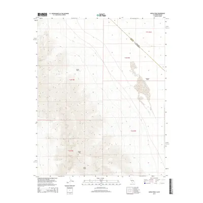
2015 Map of Nopah Peak
USGS Topo · Published 2015About this map
Nopah Peak stands as the dominant topographical feature of this desert landscape, marking the high ground of the Nopah Range along the California and Nevada border. This 2015 survey captures the transition from the steep, ridged terrain of the mountains into the arid expanse of the Mojave Desert. To the east, the landscape descends into the Pahrump Valley, where the state line cuts diagonally across the basin. The map illustrates the jurisdictional meeting point of Nye Co, Nevada, and Inyo Co, California, providing a precise look at the remote boundary lines in this part of the Great Basin. While lacking in human-made structures, the map is a detailed study of natural drainage patterns and the complex contours of the desert peaks.
Find a feature on this map
11 named features on this map. Tap any name to fly to it.
Don’t see what you’re looking for? This feature index may not catch every label — zoom into the map to look around manually.
Map Details
Editions of this 2015 Nopah Peak Map
This is the sole edition of this map. No revisions or reprints were ever made.
Other maps of this area
1907 · Las Vegas
USGS Topo · 1:250,000

1908 · Furnace Creek
USGS Topo · 1:250,000
1908 · Las Vegas
USGS Topo · 1:250,000

1910 · Furnace Creek
USGS Topo · 1:250,000

1910 · Ivanpah
USGS Topo · 1:250,000

1912 · Ivanpah
USGS Topo · 1:250,000

1933 · Avawatz Mountains
USGS Topo · 1:250,000

1942 · Ivanpah
USGS Topo · 1:250,000

1947 · Trona
USGS Topo · 1:250,000

1947 · Kingman
USGS Topo · 1:250,000