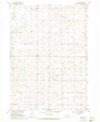
1969 Map of Nora
USGS Topo · Published 1971About this map
The small settlement of Nora serves as the central point of this southeastern South Dakota landscape, surveyed in the late 1960s. The region is defined by a dense network of local schools and churches that once anchored these rural townships, including Nora Sch, Star Sch, and St Josephs Ch near Emmet. The topography is shaped by the drainage of Brule Creek and its forks, W Brule Creek and E Brule Creek, which carve through the townships of Emmet, Alcester, and Big Springs. This map is particularly notable for its documentation of early education infrastructure before district consolidation, preserving the locations of Ludwig Sch, Garland Sch, and North Spink Sch alongside family and community burial grounds like Peace Cem and Nora Cem.
Find a feature on this map
22 named features on this map. Tap any name to fly to it.
Don’t see what you’re looking for? This feature index may not catch every label — zoom into the map to look around manually.
Map Details
Editions of this 1969 Nora Map
This is the sole edition of this map. No revisions or reprints were ever made.
Other maps of this area

1897 · Canton
USGS Topo · 1:125,000

1898 · Elk Point
USGS Topo · 1:125,000

1900 · Canton
USGS Topo · 1:125,000

1901 · Elk Point
USGS Topo · 1:125,000

1907 · Elk Point
USGS Topo · 1:125,000

1955 · Sioux City
USGS Topo · 1:250,000

1955 · Sioux Falls
USGS Topo · 1:250,000

1958 · Sioux City
USGS Topo · 1:250,000

1958 · Sioux Falls
USGS Topo · 1:250,000

1959 · Sioux City
USGS Topo · 1:250,000