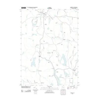
2012 Map of Norfolk
USGS Topo · Published 2012About this map
The settlement of Norfolk and the surrounding Litchfield County uplands are defined by a complex network of glacial ponds and mountain ridges. This 2012 survey illustrates a landscape where early colonial routes like the Old Waterbury Tpke and Old Colony Rd intersect with the modern recreational footprint of Camp Berger and Camp Wa-nee. Numerous family and community burial grounds, including Center Cem, Danbury Quarter Cem, and Hall Meadow Cem, are scattered across the terrain, offering significant data points for genealogical research. The drainage patterns of the Blackberry River and the E Br Naugatuck River underscore the area's historical reliance on water power, while prominent elevations such as Dutton Mountain and Pine Mountain separate the small clusters of Winchester Center, Grantville, and South Norfolk.
Find a feature on this map
118 named features on this map. Tap any name to fly to it.
Don’t see what you’re looking for? This feature index may not catch every label — zoom into the map to look around manually.
Map Details
Editions of this 2012 Norfolk Map
This is the sole edition of this map. No revisions or reprints were ever made.
Other maps of this area

1885 · Sheffield
USGS Topo · 1:62,500

1888 · Sheffield
USGS Topo · 1:62,500

1888 · Sandisfield
USGS Topo · 1:62,500

1891 · Sheffield
USGS Topo · 1:62,500

1892 · Winsted
USGS Topo · 1:62,500

1892 · Cornwall
USGS Topo · 1:62,500

1893 · Sheffield
USGS Topo · 1:62,500

1893 · Cornwall
USGS Topo · 1:62,500

1893 · Sandisfield
USGS Topo · 1:62,500

1897 · Sandisfield
USGS Topo · 1:62,500