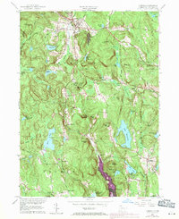
1965 Map of Norfolk
USGS Topo · Published 1971About this map
The Blackberry River flows through a landscape defined by steep wooded slopes and early recreational camps in this mid-century survey of the Litchfield hills. The settlement of Norfolk sits at the northern crossroads, while small hamlets like South Norfolk and Grantville dot the valleys to the south. Land use here is a mix of protected conservation areas and summer retreats, evidenced by Haystack Mtn State Park and Camp Wahnee.
Find a feature on this map
72 named features on this map. Tap any name to fly to it.
Don’t see what you’re looking for? This feature index may not catch every label — zoom into the map to look around manually.
Map Details
Editions of this 1965 Norfolk Map
This is the sole edition of this map. No revisions or reprints were ever made.
Other maps of this area

1885 · Sheffield
USGS Topo · 1:62,500

1888 · Sheffield
USGS Topo · 1:62,500

1888 · Sandisfield
USGS Topo · 1:62,500

1891 · Sheffield
USGS Topo · 1:62,500

1892 · Winsted
USGS Topo · 1:62,500

1892 · Cornwall
USGS Topo · 1:62,500

1893 · Sheffield
USGS Topo · 1:62,500

1893 · Cornwall
USGS Topo · 1:62,500

1893 · Sandisfield
USGS Topo · 1:62,500

1897 · Sandisfield
USGS Topo · 1:62,500