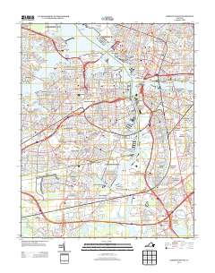
2013 Map of Norfolk South
USGS Topo · Published 2013About this map
Lamberts Point Terminal and the sprawling industrial waterfront of the Elizabeth River dominate this modern geographic study of the Hampton Roads area. The map illustrates a landscape shaped by maritime commerce and heavy transit, from the Midtown Tunnel and Downtown Tunnel to the complex network of lifting spans including the Jordan Bridge and Gilmerton Bridge. Deep-water navigation channels like the Port Norfolk Reach and Upper Reach carve through the center, separating established residential neighborhoods like Cradock and Waterview from the specialized terminals at Money Point. The geography reveals a dense suburban and industrial mosaic, where smaller waterways like Saint Julian Creek and Deep Creek thread between communities such as Gilmerton and Cavalier Manor, documenting the region's continuous evolution around its vital estuary and shipping lanes.
Find a feature on this map
116 named features on this map. Tap any name to fly to it.
Don’t see what you’re looking for? This feature index may not catch every label — zoom into the map to look around manually.
Map Details
Editions of this 2013 Norfolk South Map
This is the sole edition of this map. No revisions or reprints were ever made.
Other maps of this area

1907 · Norfolk
USGS Topo · 1:125,000

1918 · Cape Henry
USGS Topo · 1:62,500

1919 · Cape Henry
USGS Topo · 1:62,500

1921 · Newport News
USGS Topo · 1:62,500

1939 · Moyock
USGS Topo · 1:62,500

1940 · Lake Drummond
USGS Topo · 1:62,500

1944 · Norfolk South
USGS Topo · 1:25,000

1945 · Lake Drummond
USGS Topo · 1:62,500

1946 · Moyock
USGS Topo · 1:62,500

1948 · Norfolk South
USGS Topo · 1:24,000