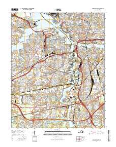
2016 Map of Norfolk South
USGS Topo · Published 2016About this map
The Tidewater region's complex maritime geography is on full display here, where the Elizabeth River and its multiple branches define the urban boundaries of Norfolk, Portsmouth, and Chesapeake. This survey details a dense network of neighborhoods such as Ghent, Brambleton, and Shea Terrace, punctuated by numerous historic burial grounds including Elmwood Cem and Calvary Cem. Educational landmarks like Norfolk State Univ and the Eastern Virginia Medical Sch sit amidst a landscape shaped by significant engineering feats, from the Midtown Tunnel to the Berkley Bridge. The map captures the industrial and naval character of the waterfront, tracing the Intracoastal Waterway and the Southern Branch Elizabeth River through areas like Cradock and Port Norfolk. This 2016 record shows the modern infrastructure of a major American port city while preserving the names of historic residential districts and points like Hospital Point and Washington Point.
Find a feature on this map
112 named features on this map. Tap any name to fly to it.
Don’t see what you’re looking for? This feature index may not catch every label — zoom into the map to look around manually.
Map Details
Editions of this 2016 Norfolk South Map
This is the sole edition of this map. No revisions or reprints were ever made.
Other maps of this area

1907 · Norfolk
USGS Topo · 1:125,000

1918 · Cape Henry
USGS Topo · 1:62,500

1919 · Cape Henry
USGS Topo · 1:62,500

1921 · Newport News
USGS Topo · 1:62,500

1939 · Moyock
USGS Topo · 1:62,500

1940 · Lake Drummond
USGS Topo · 1:62,500

1944 · Norfolk South
USGS Topo · 1:25,000

1945 · Lake Drummond
USGS Topo · 1:62,500

1946 · Moyock
USGS Topo · 1:62,500

1948 · Norfolk South
USGS Topo · 1:24,000