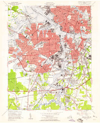
1955 Map of Norfolk South
USGS Topo · Published 1958About this map
The Elizabeth River dominates this mid-century portrait of a major Tidewater maritime hub, where the City of Norfolk, City of Portsmouth, and City of South Norfolk converge. The landscape is defined by its deep-water infrastructure and military presence, notably the sprawling U S Naval Reservation Norfolk Naval Shipyard and the U S Naval Res Naval Hospital at Hospital Point. Extensive rail networks, including the Norfolk and Western and the Virginian, thread through industrial corridors and residential neighborhoods like Ghent and Berkley. To the south, the terrain transitions into the northern reaches of the Dismal Swamp and the Intracoastal Waterway, where smaller settlements like Portlock and Gilmerton Sch appear alongside family-named landmarks such as Edmunds Corner and Dozier Corner.
Find a feature on this map
138 named features on this map. Tap any name to fly to it.
Don’t see what you’re looking for? This feature index may not catch every label — zoom into the map to look around manually.
Map Details
Editions of this 1955 Norfolk South Map
This is the sole edition of this map. No revisions or reprints were ever made.
Other maps of this area

1907 · Norfolk
USGS Topo · 1:125,000

1918 · Cape Henry
USGS Topo · 1:62,500

1919 · Cape Henry
USGS Topo · 1:62,500

1921 · Newport News
USGS Topo · 1:62,500

1939 · Moyock
USGS Topo · 1:62,500

1940 · Lake Drummond
USGS Topo · 1:62,500

1944 · Norfolk South
USGS Topo · 1:25,000

1945 · Lake Drummond
USGS Topo · 1:62,500

1946 · Moyock
USGS Topo · 1:62,500

1948 · Norfolk South
USGS Topo · 1:24,000