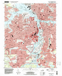
1994 Map of Norfolk South
USGS Topo · Published 2000About this map
The deep maritime identity of Chesapeake, Norfolk, and Portsmouth is fully realized here along the banks of the Elizabeth River. This mid-1990s landscape is dominated by heavy naval infrastructure and terminal facilities, including the massive U S Naval Shipyard and the U S Naval Ammunition Depot. The intricate network of the Southern Branch and Eastern Branch defines the movement of industry and commerce, from the Lamberts Point Terminal to the Deep Creek Waterway.
Find a feature on this map
170 named features on this map. Tap any name to fly to it.
Don’t see what you’re looking for? This feature index may not catch every label — zoom into the map to look around manually.
Map Details
Editions of this 1994 Norfolk South Map
This is the sole edition of this map. No revisions or reprints were ever made.
Other maps of this area

1907 · Norfolk
USGS Topo · 1:125,000

1918 · Cape Henry
USGS Topo · 1:62,500

1919 · Cape Henry
USGS Topo · 1:62,500

1921 · Newport News
USGS Topo · 1:62,500

1939 · Moyock
USGS Topo · 1:62,500

1940 · Lake Drummond
USGS Topo · 1:62,500

1944 · Norfolk South
USGS Topo · 1:25,000

1945 · Lake Drummond
USGS Topo · 1:62,500

1946 · Moyock
USGS Topo · 1:62,500

1948 · Norfolk South
USGS Topo · 1:24,000