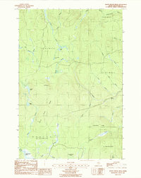
1986 Map of North Brook Ridge
USGS Topo · Published 1987About this map
North Brook Ridge and Carmichael Ridge define the rugged topography of this unorganized territory in northern Maine. The landscape is dominated by a complex network of waterways, including the Meduxnekeag River and its North Branch, which drain the dense woods of Dudley and Hammond. Grounded in data from mid-century aerial photography, the map reveals a remote environment where human presence is largely limited to logging tracks like Carlisle Road and isolated points like Collis. Notable water bodies such as Scott Pond, Little Fowler Pond, and the expansive Thousand Acre Swamp illustrate the drainage patterns typical of this glacial terrain. The lack of formal towns and the prevalence of township designations like T 8 R 3 W E L S underscore the area's history as a managed timberland rather than a settled agricultural district.
Find a feature on this map
32 named features on this map. Tap any name to fly to it.
Don’t see what you’re looking for? This feature index may not catch every label — zoom into the map to look around manually.
Map Details
Editions of this 1986 North Brook Ridge Map
This is the sole edition of this map. No revisions or reprints were ever made.
Other maps of this area

1934 · Bridgewater
USGS Topo · 1:48,000

1935 · Howe Brook
USGS Topo · 1:48,000

1937 · Smyrna Mills
USGS Topo · 1:62,500

1938 · Bridgewater
USGS Topo · 1:62,500

1938 · Houlton
USGS Topo · 1:62,500

1939 · Howe Brook
USGS Topo · 1:62,500

1951 · Houlton
USGS Topo · 1:62,500

1951 · Bridgewater
USGS Topo · 1:62,500

1953 · Bridgewater
USGS Topo · 1:50,000

1954 · Howe Brook
USGS Topo · 1:62,500