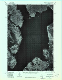
1977 Map of North East Carry
USGS Topo · Published 1981About this map
Moosehead Lake dominates this late-1970s orthophotoquad, revealing the wooded shoreline and deep waters of Maine's northern wilderness. The photography, captured by the Geological Survey in November 1977, provides a clear view of the land-water interface at North East Carry, a traditional transit point between the lake and the Penobscot River system. Along the southern edge, the clearing at Folsom Farm stands out against the dense forest cover, indicating a history of localized land use in this timber-rich region. The terrain is defined by the rise of Eagle Mountain to the east and the coastal indentation of Ogontz on the western shore. Minor drainages like Williams Brook feed into the northern reaches of the lake, illustrating the complex hydrology of the Maine woods before modern development reached this remote sector.
Find a feature on this map
6 named features on this map. Tap any name to fly to it.
Don’t see what you’re looking for? This feature index may not catch every label — zoom into the map to look around manually.
Map Details
Editions of this 1977 North East Carry Map
This is the sole edition of this map. No revisions or reprints were ever made.
Other maps of this area

1920 · Moosehead Lake
USGS Topo · 1:62,500

1921 · Brassua Lake
USGS Topo · 1:62,500

1922 · Moosehead Lake
USGS Topo · 1:62,500

1923 · Brassua Lake
USGS Topo · 1:62,500

1930 · Moosehead Lake
USGS Topo · 1:62,500

1944 · Brassua Lake
USGS Topo · 1:62,500

1944 · Moosehead Lake
USGS Topo · 1:62,500

1954 · Seboomook Lake
USGS Topo · 1:62,500

1954 · North East Carry
USGS Topo · 1:62,500

1954 · Millinocket
USGS Topo · 1:250,000
Featured Places
- Tomhegan Township, ME
- Days Academy Grant Township, ME
- Northeast Carry Township, ME
- East Middlesex Canal Grant Township, ME
- Ogontz, Big W Township