
1944 Map of Brassua Lake
USGS Topo · Published 1944About this map
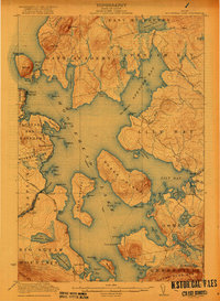
The Canadian Pacific railroad cuts through the center of this Maine backcountry, establishing the vital junction at Somerset Junction Tarratine P O. During the mid-1940s, this region was characterized by its timber and sporting camps, including Maynard Camp, Page Camp, and Sperry Camp along the shores of Little Brassua Lake and Moosehead Lake. Local education is anchored by the Blaine Sch near the eastern shoreline, while agricultural operations like Cornish Farm and Milliken Farm suggest a landscape where small-scale farming persisted alongside large-scale land management in the 10000 Acre Tract. The presence of numerous camps, such as Warren Camp and McDonald Camp, reflects the area's identity as a hub for wilderness recreation and logging activity, centered around the Kennebec River and the towering height of Big Squaw Mountain.
Find a feature on this map
50 named features on this map. Tap any name to fly to it.
Don’t see what you’re looking for? This feature index may not catch every label — zoom into the map to look around manually.
Map Details
Editions of this 1944 Brassua Lake Map
This is the sole edition of this map. No revisions or reprints were ever made.
Other maps of this area

1905 · The Forks
USGS Topo · 1:62,500

1907 · The Forks
USGS Topo · 1:62,500

1920 · Moosehead Lake
USGS Topo · 1:62,500

1921 · Brassua Lake
USGS Topo · 1:62,500
1922 · Moosehead Lake
USGS Topo · 1:62,500

1922 · Long Pond
USGS Topo · 1:62,500

1923 · Brassua Lake
USGS Topo · 1:62,500

1924 · Long Pond
USGS Topo · 1:62,500

1925 · Pierce Pond
USGS Topo · 1:48,000

1927 · Pierce Pond
USGS Topo · 1:62,500
Featured Places
- Misery Gore, ME
- Tomhegan Township, ME
- Sapling Township, ME
- Big Moose Township, ME
- Tarratine, Taunton & Raynham Academy Grant