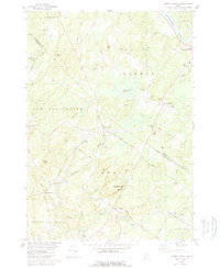
1979 Map of North Pownal
USGS Topo · Published 1979About this map
The Androscoggin River defines the northeast corner of this 1979 survey, where the settlement of South West Bend sits near the border of Lisbon and Durham. The landscape is a network of small watersheds including Meadow Brook, Libby Brook, and Gerrish Brook, punctuated by prominent heights such as McKenney Hill and Tryon Mtn. Central to the area is Bradbury Mtn State Park, located just south of North Pownal.
Find a feature on this map
66 named features on this map. Tap any name to fly to it.
Don’t see what you’re looking for? This feature index may not catch every label — zoom into the map to look around manually.
Map Details
Editions of this 1979 North Pownal Map
2 editions found
Other maps of this area

1892 · Freeport
USGS Topo · 1:62,500

1894 · Gray
USGS Topo · 1:62,500

1898 · Gray
USGS Topo · 1:62,500

1908 · Poland
USGS Topo · 1:62,500

1908 · Lewiston
USGS Topo · 1:62,500

1940 · Poland
USGS Topo · 1:62,500

1941 · Freeport
USGS Topo · 1:62,500

1942 · Lewiston
USGS Topo · 1:62,500

1942 · Poland
USGS Topo · 1:62,500

1942 · Gray
USGS Topo · 1:62,500