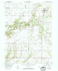
1958 Map of North Salem
USGS Topo · Published 1984About this map
North Salem serves as the primary hub in this mid-century portrait of the rural borderlands between Hendricks, Montgomery, and Putnam Counties. The northern landscape is defined by the Baltimore and Ohio railroad corridor, which links the small communities of Barnard and North Salem through a network of grain elevators and local depots. Agricultural life is anchored by family and community landmarks such as Mt Olivet Ch and several rural burying grounds including Fairview Cem and Biddle Cem.
Find a feature on this map
28 named features on this map. Tap any name to fly to it.
Don’t see what you’re looking for? This feature index may not catch every label — zoom into the map to look around manually.
Map Details
Editions of this 1958 North Salem Map
Other maps of this area

1953 · Clayton
USGS Topo · 1:24,000

1953 · Lizton
USGS Topo · 1:24,000

1953 · Danville
USGS Topo · 1:24,000

1953 · Indianapolis
USGS Topo · 1:250,000

1956 · Indianapolis
USGS Topo · 1:250,000

1957 · Indianapolis
USGS Topo · 1:250,000

1957 · New Ross
USGS Topo · 1:24,000

1958 · Roachdale
USGS Topo · 1:24,000

1958 · Ladoga
USGS Topo · 1:24,000

1958 · Coatesville
USGS Topo · 1:24,000