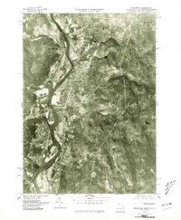
1975 Map of Northfield
USGS Topo · Published 1981About this map
The Connecticut River winds through the heart of this mid-1970s orthophotoquad, defining the valley landscape between the highlands of Notch Mtn and Hogback Mtn. This aerial perspective reveals the precise arrangement of agricultural fields and riverfront development in Northfield and West Northfield as they appeared toward the end of the century. The imagery provides an unfiltered view of the land-use patterns, highlighting the proximity of the rail-linked Gill Station and the rural crossroads of Curtis Corner to the water. To the south, the terrain rises toward Crag Mtn, showcasing the dense woodland that borders the established settlements of Gill. This specific photographic record preserves the exact footprint of small-town Massachusetts infrastructure before later decades of growth and reforestation altered the visual character of the valley.
Find a feature on this map
9 named features on this map. Tap any name to fly to it.
Don’t see what you’re looking for? This feature index may not catch every label — zoom into the map to look around manually.
Map Details
Editions of this 1975 Northfield Map
This is the sole edition of this map. No revisions or reprints were ever made.
Other maps of this area

1887 · Warwick
USGS Topo · 1:62,500

1889 · Warwick
USGS Topo · 1:62,500

1890 · Greenfield
USGS Topo · 1:62,500

1891 · Brattleboro
USGS Topo · 1:62,500

1893 · Brattleboro
USGS Topo · 1:62,500

1894 · Greenfield
USGS Topo · 1:62,500

1894 · Warwick
USGS Topo · 1:62,500

1898 · Keene
USGS Topo · 1:62,500

1932 · Brattleboro
USGS Topo · 1:48,000

1932 · Warwick
USGS Topo · 1:48,000