
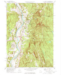
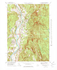
1977 Map of Northfield
USGS Topo · Published 1984About this map
The Connecticut River serves as the central artery for this tri-state borderland, where the boundaries of Massachusetts, Vermont, and New Hampshire converge. The landscape is characterized by its broad agricultural bottomlands like Beers Plain and Pauchaug Meadow, which contrast sharply with the rising elevations of Stratton Mountain and the Bald Hills to the east. The settlement of Northfield is well-established here, anchored by institutional landmarks such as the Northfield Sch and the Pioneer Valley Regional Sch.
Find a feature on this map
75 named features on this map. Tap any name to fly to it.
Don’t see what you’re looking for? This feature index may not catch every label — zoom into the map to look around manually.
Map Details
Editions of this 1977 Northfield Map
3 editions found
Other maps of this area

1887 · Warwick
USGS Topo · 1:62,500

1889 · Warwick
USGS Topo · 1:62,500

1890 · Greenfield
USGS Topo · 1:62,500

1891 · Brattleboro
USGS Topo · 1:62,500

1893 · Brattleboro
USGS Topo · 1:62,500

1894 · Greenfield
USGS Topo · 1:62,500

1894 · Warwick
USGS Topo · 1:62,500

1898 · Keene
USGS Topo · 1:62,500

1932 · Brattleboro
USGS Topo · 1:48,000

1932 · Warwick
USGS Topo · 1:48,000