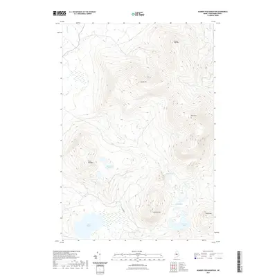
2021 Map of Number Four Mountain
USGS Topo · Published 2021About this map
Number Four Mtn dominates the skyline of this northern Maine landscape, serving as a prominent anchor in a chain of peaks that includes Lily Bay Mtn and Elephant Mtn. The terrain is defined by its high-elevation summits and a dense network of glacial water bodies collected in the valleys below. Major basins like Upper Wilson Pond and Mountain Pond are fed by drainages such as N Brook and S Brook, reflecting a primitive hydrographic system. A single primary access route, Scammon Rd, provides the only significant roadway through this interior wilderness. Local geography is further marked by several smaller, secluded water features, including Pearl Ponds, Lost Pond, and the uniquely shaped Horseshoe Pond, each set against the steep slopes of Baker Mtn and Indian Mtn.
Find a feature on this map
18 named features on this map. Tap any name to fly to it.
Don’t see what you’re looking for? This feature index may not catch every label — zoom into the map to look around manually.
Map Details
Editions of this 2021 Number Four Mountain Map
This is the sole edition of this map. No revisions or reprints were ever made.
Other maps of this area

1920 · Moosehead Lake
USGS Topo · 1:62,500

1922 · Moosehead Lake
USGS Topo · 1:62,500

1930 · Moosehead Lake
USGS Topo · 1:62,500

1944 · Moosehead Lake
USGS Topo · 1:62,500

1950 · Sebec Lake
USGS Topo · 1:62,500

1951 · Greenville
USGS Topo · 1:62,500

1952 · First Roach Pond
USGS Topo · 1:62,500

1954 · Millinocket
USGS Topo · 1:250,000

1957 · Moosehead Lake
USGS Topo · 1:62,500

1958 · Millinocket
USGS Topo · 1:250,000
Featured Places
- Greenville, ME
- Beaver Cove, ME
- Frenchtown Township, ME
- Lily Bay Township, ME
- Bowdoin College Grant East Township, ME