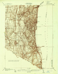
1937 Map of Nyack
USGS Topo · Published 1937About this map
The steep cliffs of the Palisades dominate the western shore of the Tappan Sea Hudson River in this 1937 survey of Rockland County. This era captures the dense network of the Erie Railroad and Northern Railroad of New Jersey as they navigate the riverfront and inland valleys through Piermont and Sparkill. The landscape is a mix of established river towns like Nyack and South Nyack and significant institutional grounds, most notably the expansive complex of the Rockland State Hospital and the nearby St Catharines Cem.
Find a feature on this map
54 named features on this map. Tap any name to fly to it.
Don’t see what you’re looking for? This feature index may not catch every label — zoom into the map to look around manually.
Map Details
Editions of this 1937 Nyack Map
This is the sole edition of this map. No revisions or reprints were ever made.
Other maps of this area

1888 · Paterson
USGS Topo · 1:62,500

1891 · Ramapo
USGS Topo · 1:62,500

1891 · Harlem
USGS Topo · 1:62,500

1892 · Paterson
USGS Topo · 1:62,500

1892 · Tarrytown
USGS Topo · 1:62,500

1893 · Tarrytown
USGS Topo · 1:62,500

1893 · Ramapo
USGS Topo · 1:62,500

1897 · Harlem
USGS Topo · 1:62,500

1898 · Harlem
USGS Topo · 1:62,500

1898 · Paterson
USGS Topo · 1:62,500