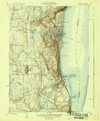
1942 Map of Nyack
USGS Topo · Published 1942About this map
Tappan Zee Hudson River dominates the eastern edge of this landscape, where the Tarrytown Ferry once connected the riverfront communities of Nyack, South Nyack, and Upper Nyack to the opposite shore. The terrain is sharply defined by the Palisades and Hook Mtn, which rise steeply above the water. Inland, the map reveals a dense network of institutional and social landmarks, from the expansive grounds of the Rockland State Hospital to the Clarkstown Country Club and the Childrens Home.
Find a feature on this map
60 named features on this map. Tap any name to fly to it.
Don’t see what you’re looking for? This feature index may not catch every label — zoom into the map to look around manually.
Map Details
Editions of this 1942 Nyack Map
This is the sole edition of this map. No revisions or reprints were ever made.
Other maps of this area

1888 · Paterson
USGS Topo · 1:62,500

1891 · Ramapo
USGS Topo · 1:62,500

1891 · Harlem
USGS Topo · 1:62,500

1892 · Paterson
USGS Topo · 1:62,500

1892 · Tarrytown
USGS Topo · 1:62,500

1893 · Tarrytown
USGS Topo · 1:62,500

1893 · Ramapo
USGS Topo · 1:62,500

1897 · Harlem
USGS Topo · 1:62,500

1898 · Harlem
USGS Topo · 1:62,500

1898 · Paterson
USGS Topo · 1:62,500