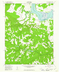
1949 Map of Occupacia
USGS Topo · Published 1961About this map
The Rappahannock River defines the northeastern boundary of this landscape, where the colonial-era heritage of Essex County is visible through its historic landmarks and rural crossroads. The area is characterized by several water bodies, including Hunters Millpond, Taliaferro Pond, and Baylors Pond, reflecting a landscape managed for local industry and agriculture. Notable ecclesiastical sites such as Vauters Ch, Mt Salem Ch, and Bethlehem Ch are distributed among the dispersed settlements, serving as anchors for the communities of Loretto, Iraville, and Hustle. The topographical transition from the river lowlands to the more dissected interior is marked by Black Water Swamp and Occupacia Creek, illustrating the natural drainage patterns that have historically shaped land use and property boundaries in this part of Virginia.
Find a feature on this map
25 named features on this map. Tap any name to fly to it.
Don’t see what you’re looking for? This feature index may not catch every label — zoom into the map to look around manually.
Map Details
Editions of this 1949 Occupacia Map
This is the sole edition of this map. No revisions or reprints were ever made.
Other maps of this area

1889 · Fredericksburg
USGS Topo · 1:125,000

1892 · Fredericksburg
USGS Topo · 1:125,000

1892 · Montross
USGS Topo · 1:62,500

1894 · Fredericksburg
USGS Topo · 1:125,000

1895 · Nomini
USGS Topo · 1:125,000

1895 · Montross
USGS Topo · 1:62,500

1898 · Nomini
USGS Topo · 1:125,000

1918 · Tappahannock
USGS Topo · 1:62,500

1918 · Aylett
USGS Topo · 1:62,500

1919 · Tappahannock
USGS Topo · 1:62,500