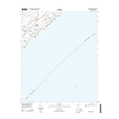
2014 Map of Ocean Forest
USGS Topo · Published 2014About this map
Myrtle Beach and the developed shoreline of Long Bay dominate this 2014 survey, illustrating the complex residential and leisure landscape of the Grand Strand. Modern residential developments like Northwood, Highlands, and Plantation Point are shown in high detail, illustrating the density of this coastal region. The map reveals the relationship between the built environment and the area's natural hydrography, specifically where Canepatch Swash and Deephead Swash reach the Atlantic Ocean. Inland, the Intracoastal Waterway serves as a major navigational boundary, separating the coastal neighborhoods from the interior. For local historians, the sheet provides a precise look at the neighborhood layouts of Washington Park, Myrtle Heights, and Ocean Forest as they existed in the early twenty-first century.
Find a feature on this map
45 named features on this map. Tap any name to fly to it.
Don’t see what you’re looking for? This feature index may not catch every label — zoom into the map to look around manually.
Map Details
Editions of this 2014 Ocean Forest Map
This is the sole edition of this map. No revisions or reprints were ever made.
Other maps of this area

1937 · Myrtle Beach
USGS Topo · 1:48,000

1937 · Nixonville
USGS Topo · 1:48,000

1940 · Myrtle Beach
USGS Topo · 1:62,500

1942 · Nixonville
USGS Topo · 1:62,500

1943 · Wampee
USGS Topo · 1:24,000

1949 · Georgetown
USGS Topo · 1:250,000

1967 · Georgetown
USGS Topo · 1:250,000

1974 · Georgetown
USGS Topo · 1:250,000
1984 · Nixonville
USGS Topo · 1:24,000
1984 · Ocean Forest
USGS Topo · 1:24,000