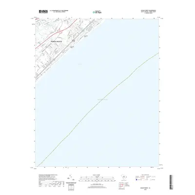
2020 Map of Ocean Forest
USGS Topo · Published 2020About this map
Myrtle Beach and the residential enclave of Ocean Forest define this stretch of the South Carolina coast, where modern development meets the complex hydrology of the Grand Strand. The map traces the critical corridor of the Intracoastal Waterway as it bypasses the shoreline, separated from the Atlantic Ocean by a grid of numbered avenues and winding residential loops like Ladybank Loop. The coastal landscape is punctuated by unique tidal inlets known as swashes, specifically Canepatch Swash and Deephead Swash, which drain the low-lying interior through Withers Swamp. This 2020 survey documents the transition from the dense urban streets of the beach front to the wooded terrain and recreational areas near The Hulk, illustrating how the region's historical natural drainage patterns continue to influence modern property boundaries and infrastructure near Long Bay.
Find a feature on this map
73 named features on this map. Tap any name to fly to it.
Don’t see what you’re looking for? This feature index may not catch every label — zoom into the map to look around manually.
Map Details
Editions of this 2020 Ocean Forest Map
This is the sole edition of this map. No revisions or reprints were ever made.
Other maps of this area

1937 · Myrtle Beach
USGS Topo · 1:48,000

1937 · Nixonville
USGS Topo · 1:48,000

1940 · Myrtle Beach
USGS Topo · 1:62,500

1942 · Nixonville
USGS Topo · 1:62,500

1943 · Wampee
USGS Topo · 1:24,000

1949 · Georgetown
USGS Topo · 1:250,000

1967 · Georgetown
USGS Topo · 1:250,000

1974 · Georgetown
USGS Topo · 1:250,000
1984 · Nixonville
USGS Topo · 1:24,000
1984 · Ocean Forest
USGS Topo · 1:24,000