1972 Map of Offerle
USGS Topo · Published 1974About this map
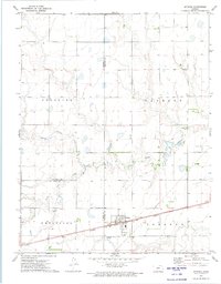
Offerle sits at the junction of rail and road in this 1970s survey, serving as a vital hub for the surrounding agricultural townships of Wheatland, Trenton, Sterling, and Jackson. The landscape is defined by the winding paths of White Woman Creek, Coon Creek, and Little Coon Creek, which carve through the plains. The influence of the Atchison Topeka and Santa Fe railroad is central to the town's geography, running parallel to the highway and anchoring the local infrastructure. Genealogists and local historians will find significant detail in the marking of St Joseph Cem and Evergreen Cem, alongside evidence of modern utility expansions like the Sewage Disposal Ponds and various Pipelines crossing the county borders of Hodgeman, Edwards, and Ford.
Find a feature on this map
19 named features on this map. Tap any name to fly to it.
Don’t see what you’re looking for? This feature index may not catch every label — zoom into the map to look around manually.
Map Details
Editions of this 1972 Offerle Map
This is the sole edition of this map. No revisions or reprints were ever made.
Other maps of this area

1889 · Larned
USGS Topo · 1:125,000

1889 · Kinsley
USGS Topo · 1:125,000

1891 · Larned
USGS Topo · 1:125,000

1892 · Ness
USGS Topo · 1:125,000

1892 · Kinsley
USGS Topo · 1:125,000

1892 · Spearville
USGS Topo · 1:125,000

1894 · Spearville
USGS Topo · 1:125,000

1894 · Kinsley
USGS Topo · 1:125,000

1894 · Ness
USGS Topo · 1:125,000

1955 · Great Bend
USGS Topo · 1:250,000