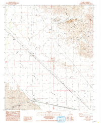
1988 Map of Ogilby
USGS Topo · Published 1988About this map
The Cargo Mucho Mountains dominate this 1980s landscape, revealing an intensive history of desert mining operations. Numerous extraction sites, including the American Girl Mine, Pasadena Mine, and the Padre Madre Mine, are connected by a network of service roads and tracks across the desert floor. The former settlement of Ogilby (Site) is marked as a historic location, complete with a local Cem and Radio Tower, while the settlement of Obregon sits further north near the American Girl Wash. In the southern portion of the quadrangle, the industrial feat of the All American Canal cuts through the desert near the Pilot Knob Mesa, providing a stark contrast to the natural shifting landscape of the Sand Dunes and the erosion patterns of the Ogilby Hills.
Find a feature on this map
28 named features on this map. Tap any name to fly to it.
Don’t see what you’re looking for? This feature index may not catch every label — zoom into the map to look around manually.
Map Details
Editions of this 1988 Ogilby Map
This is the sole edition of this map. No revisions or reprints were ever made.
Other maps of this area

1903 · Yuma
USGS Topo · 1:125,000

1905 · Yuma
USGS Topo · 1:125,000

1940 · Yuma
USGS Topo · 1:62,500

1942 · Yuma
USGS Topo · 1:250,000

1945 · Picacho Peak
USGS Topo · 1:62,500

1945 · Yuma
USGS Topo · 1:62,500

1951 · Picacho Peak
USGS Topo · 1:62,500

1952 · Araz
USGS Topo · 1:24,000

1952 · Yuma West
USGS Topo · 1:24,000

1953 · Grays Well
USGS Topo · 1:24,000