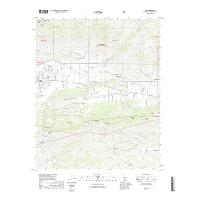
2018 Map of Ojai
USGS Topo · Published 2018About this map
Ojai and the surrounding Ojai Valley are defined by the dramatic meeting of citrus groves and steep mountain slopes within the Los Padres National Forest. The 2018 survey reveals a landscape of water management and education, with the Senior Canyon Reservoir and Lion Canyon Reservoir tucked into the canyons to support the valley's agriculture. Notable landmarks include the Nordhoff Peak fire lookout area and various private institutions such as the Ojai Valley School and Happy Valley School. To the south, the terrain rises into the ridge of Sulphur Mtn, separating the main valley from Upper Ojai Valley. This map documents a community that balances its wild boundaries, like Cozy Dell Canyon and Horn Canyon, with a precise grid of roads such as Grand Ave and Thacher Rd that navigate the alluvial fans.
Find a feature on this map
98 named features on this map. Tap any name to fly to it.
Don’t see what you’re looking for? This feature index may not catch every label — zoom into the map to look around manually.
Map Details
Editions of this 2018 Ojai Map
This is the sole edition of this map. No revisions or reprints were ever made.
Other maps of this area

1903 · Santa Paula
USGS Topo · 1:62,500

1903 · Mt. Pinos
USGS Topo · 1:125,000

1904 · Ventura
USGS Topo · 1:62,500

1941 · Ventura
USGS Topo · 1:62,500

1942 · Santa Paula
USGS Topo · 1:62,500

1942 · Wheeler Springs
USGS Topo · 1:24,000

1943 · Topatopa Mountains
USGS Topo · 1:24,000

1943 · Lion Canyon
USGS Topo · 1:24,000

1943 · Wheeler Springs
USGS Topo · 1:24,000
1944 · Wheeler Springs
USGS Topo · 1:31,680