1998 Map of Old Town
USGS Topo · Published 2001About this map
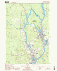
The Penobscot River and its intricate branches define this portion of Penobscot County, where the waterway splits around Marsh Island and Orson Island. At the heart of the map lies Old Town, a historic industrial and social hub situated across from the Penobscot Indian Reservation on Indian Island. The area’s educational and transportation identity is clear, with the southern reaches featuring the Univ of Maine campus and aviation activity centered at Dewitt Field.
Find a feature on this map
52 named features on this map. Tap any name to fly to it.
Don’t see what you’re looking for? This feature index may not catch every label — zoom into the map to look around manually.
Map Details
Editions of this 1998 Old Town Map
This is the sole edition of this map. No revisions or reprints were ever made.
Other maps of this area

1902 · Orono
USGS Topo · 1:62,500

1902 · Bangor
USGS Topo · 1:62,500

1917 · Passadumkeag
USGS Topo · 1:62,500

1933 · Boyd Lake
USGS Topo · 1:62,500

1942 · Bangor
USGS Topo · 1:62,500

1944 · Orono
USGS Topo · 1:62,500

1946 · Bangor
USGS Topo · 1:62,500

1946 · Orono
USGS Topo · 1:62,500

1948 · Bangor
USGS Topo · 1:250,000

1951 · Boyd Lake
USGS Topo · 1:50,000