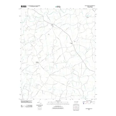
2010 Map of Olive Branch
USGS Topo · Published 2010About this map
Olive Branch serves as a central point in this rural North Carolina landscape, where small crossroads and family landmarks define the community structure. The map documents a terrain deeply carved by water, with Richardson Creek and Gourdvine Creek draining the rolling land toward Lanes Creek in the south. For local historians, the placement of Baucoms Cemetery and Davis Cemetery alongside roads like Jerusalem Church Rd and Fountain Hill Church RD indicates the traditional gathering places that have anchored these settlements for generations. The presence of Old Goldmine Rd suggests a history of local resource extraction, while Jones Pond Dam and the various branches like Little Water Branch reflect the importance of water management in this agricultural region. Small hubs like Hamilton Crossroads and Fountain Hill illustrate the persistent importance of early intersections in rural transportation networks.
Find a feature on this map
57 named features on this map. Tap any name to fly to it.
Don’t see what you’re looking for? This feature index may not catch every label — zoom into the map to look around manually.
Map Details
Editions of this 2010 Olive Branch Map
This is the sole edition of this map. No revisions or reprints were ever made.
Other maps of this area

1941 · Spartanburg
USGS Topo · 1:250,000

1953 · Spartanburg
USGS Topo · 1:250,000

1953 · Charlotte
USGS Topo · 1:250,000

1954 · Charlotte
USGS Topo · 1:250,000

1960 · Charlotte
USGS Topo · 1:250,000

1960 · Spartanburg
USGS Topo · 1:250,000

1962 · Charlotte
USGS Topo · 1:250,000

1963 · Spartanburg
USGS Topo · 1:250,000

1964 · Spartanburg
USGS Topo · 1:250,000
1970 · Watson
USGS Topo · 1:24,000