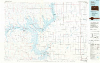
1986 Map of Onida
USGS Topo · Published 1986About this map
Lake Oahe dominates the central landscape of this 1980s-era map, where the impounded Missouri River meets the winding Cheyenne River. The western portion of the map is defined by the high plateaus of Mission Ridge and Orton Flat, punctuated by isolated landmarks like No Heart Butte and Standing Butte. To the east, the grain-farming prairie of Sully County is organized by a rigid grid of roads, centered on the county seat at Onida and the small agricultural hubs of Agar and Gorman. The Chicago and North Western railroad line cuts through this plains country, providing a vital link for the scattered settlements. Extensive recreational and conservation lands, including the Sutton State Game Production Area and the Okobojo Recreation Area, border the reservoir, reflecting the region's mid-century transition toward water-based recreation and wildlife management.
Find a feature on this map
67 named features on this map. Tap any name to fly to it.
Don’t see what you’re looking for? This feature index may not catch every label — zoom into the map to look around manually.
Map Details
Editions of this 1986 Onida Map
2 editions found
Other maps of this area

1924 · Pierre
USGS Topo · 1:62,500

1934 · Canning
USGS Topo · 1:48,000

1937 · Canning
USGS Topo · 1:62,500

1937 · Oahe
USGS Topo · 1:62,500

1953 · Huron
USGS Topo · 1:250,000

1953 · McIntosh
USGS Topo · 1:250,000

1954 · Aberdeen
USGS Topo · 1:250,000

1954 · Pierre
USGS Topo · 1:250,000

1954 · Huron
USGS Topo · 1:250,000

1956 · Aberdeen
USGS Topo · 1:250,000