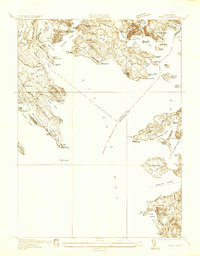
1936 Map of Onset
USGS Topo · Published 1936About this map
Buzzards Bay dominates this coastal landscape, shaping a shoreline defined by intricate inlets, peninsulas, and summer colonies as they appeared in the mid-1930s. The dense resort settlement of Onset and neighboring Point Independence anchor the northern reaches, where the Wareham River meets the bay. This period of coastal development is marked by recreational landmarks such as the Beverly Yacht Club and Kitterset Golf Club, alongside working maritime features like the Wings Neck Lighthouse. Further south, the map details the emerging seasonal communities at Silver Beach and Old Silver Beach. Inland, the presence of Stones Bog near the Weweantic River hints at the regional importance of cranberry cultivation. The geography is punctuated by numerous islands, including Mashnee Island and Wickets Island, and prominent overlooks like Bourne Hill, providing a detailed view of the Plymouth and Barnstable County border before later modern developments altered the coast.
Find a feature on this map
97 named features on this map. Tap any name to fly to it.
Don’t see what you’re looking for? This feature index may not catch every label — zoom into the map to look around manually.
Map Details
Editions of this 1936 Onset Map
This is the sole edition of this map. No revisions or reprints were ever made.
Other maps of this area

1885 · New Bedford
USGS Topo · 1:62,500

1885 · Middleboro
USGS Topo · 1:62,500

1886 · Falmouth
USGS Topo · 1:62,500

1886 · Plymouth
USGS Topo · 1:62,500

1888 · New Bedford
USGS Topo · 1:62,500

1888 · Falmouth
USGS Topo · 1:62,500

1888 · Middleboro
USGS Topo · 1:62,500

1889 · Plymouth
USGS Topo · 1:62,500

1893 · Middleboro
USGS Topo · 1:62,500

1893 · Falmouth
USGS Topo · 1:62,500