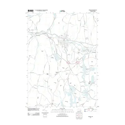
2012 Map of Orange
USGS Topo · Published 2012About this map
Millers River serves as the primary drainage and historical industrial corridor for this region, passing through the villages of West Orange and Wendell Depot. To the south, the landscape is defined by the northern reaches of the Quabbin Reservoir, where many old roads and farmsteads were lost to the creation of the massive water project. These inundated areas and their surrounding highlands, including Rattlesnake Hill and Harris Hill, demonstrate the transition from the agricultural past of North New Salem and Morse Village to a more conservation-focused landscape. Small water bodies like Lake Mattawa and Lake Rohunta provide a counterpoint to the larger reservoir, surrounded by named ridges such as North Pond Ridge. Genealogists and local historians can trace the network of old rural routes, such as Wendell Rd and Morse Village Rd, connecting the scattered settlements of Eaglesville and South Athol with the local burial grounds at Branch Cem.
Find a feature on this map
163 named features on this map. Tap any name to fly to it.
Don’t see what you’re looking for? This feature index may not catch every label — zoom into the map to look around manually.
Map Details
Editions of this 2012 Orange Map
This is the sole edition of this map. No revisions or reprints were ever made.
Other maps of this area

1887 · Warwick
USGS Topo · 1:62,500

1887 · Belchertown
USGS Topo · 1:62,500

1887 · Winchendon
USGS Topo · 1:62,500

1887 · Barre
USGS Topo · 1:62,500

1889 · Barre
USGS Topo · 1:62,500

1889 · Warwick
USGS Topo · 1:62,500

1890 · Belchertown
USGS Topo · 1:62,500

1890 · Winchendon
USGS Topo · 1:62,500

1893 · Belchertown
USGS Topo · 1:62,500

1894 · Winchendon
USGS Topo · 1:62,500