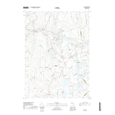
2018 Map of Orange
USGS Topo · Published 2018About this map
The Millers River corridor serves as the industrial and transit spine for this part of the Massachusetts interior, connecting Orange to West Orange and the outlying Wendell Depot. This modern topographic survey highlights a landscape defined by significant elevation changes, from the prominent Fall Hill in the north to the cluster of peaks around North Pond Ridge and The Bears Den. While the northern section is anchored by the developed center and the Orange Municipal Airport, the southern reaches transition into a network of ponds and wetlands, including North Spectacle Pond and South Spectacle Pond near South Athol. Notable for local historians, the map preserves the locations of several smaller hamlets and rural gathering points such as Morse Village, North New Salem, and the historic Branch Cemetery, showing how the rugged terrain influenced the placement of roads like the Mohawk Trail.
Find a feature on this map
158 named features on this map. Tap any name to fly to it.
Don’t see what you’re looking for? This feature index may not catch every label — zoom into the map to look around manually.
Map Details
Editions of this 2018 Orange Map
This is the sole edition of this map. No revisions or reprints were ever made.
Other maps of this area

1887 · Warwick
USGS Topo · 1:62,500

1887 · Belchertown
USGS Topo · 1:62,500

1887 · Winchendon
USGS Topo · 1:62,500

1887 · Barre
USGS Topo · 1:62,500

1889 · Barre
USGS Topo · 1:62,500

1889 · Warwick
USGS Topo · 1:62,500

1890 · Belchertown
USGS Topo · 1:62,500

1890 · Winchendon
USGS Topo · 1:62,500

1893 · Belchertown
USGS Topo · 1:62,500

1894 · Winchendon
USGS Topo · 1:62,500