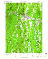
1948 Map of Orange
USGS Topo · Published 1961About this map
Orange serves as the industrial and social hub of this territory, situated along the Millers River and the Boston and Maine Railroad. The landscape is defined by its transition toward the southern reaches of the Quabbin Reservoir, where the Swift River flows through a series of valleys flanked by prominent ridges like North Pond Ridge and Rattlesnake Hill. This 1948 revision reveals a region navigating mid-century modernization, most notably with the expansion of the Orange Municipal Airport and the prominence of the Daniel Shays Highway. For those tracing local heritage, the map identifies small clusters of settlement such as Wendell Depot and Morse Village, alongside family-named sites like Jones Cem and the Wilbur Cem near Fisk Hill. The presence of the Morgan Memorial and various CCC camps indicates a landscape managed for both social welfare and conservation in the post-war era.
Find a feature on this map
63 named features on this map. Tap any name to fly to it.
Don’t see what you’re looking for? This feature index may not catch every label — zoom into the map to look around manually.
Map Details
Editions of this 1948 Orange Map
2 editions found
Other maps of this area

1887 · Warwick
USGS Topo · 1:62,500

1887 · Belchertown
USGS Topo · 1:62,500

1887 · Winchendon
USGS Topo · 1:62,500

1887 · Barre
USGS Topo · 1:62,500

1889 · Barre
USGS Topo · 1:62,500

1889 · Warwick
USGS Topo · 1:62,500

1890 · Belchertown
USGS Topo · 1:62,500

1890 · Winchendon
USGS Topo · 1:62,500

1893 · Belchertown
USGS Topo · 1:62,500

1894 · Winchendon
USGS Topo · 1:62,500