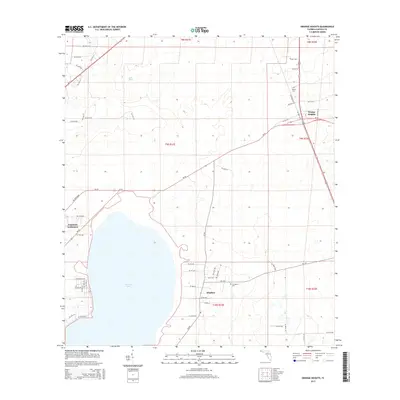
2015 Map of Orange Heights
USGS Topo · Published 2015About this map
Newnans Lake dominates the southwestern quadrant of this landscape, its northern shoreline met by the waters of Hatchet Creek. To the east, the rural settlements of Orange Heights, Windsor, and Copeland Settlement are connected by a network of state and county routes including SR-26 and CR-234. Local history is preserved in small burial grounds like Saluda Cem near the northern boundary and Providence Cem situated just east of Windsor. The terrain is marked by unusual features such as Lake Mize, a small isolated body of water north of the main lake. This survey documents the area's mid-decade character, showing the distribution of homesteads and local roads like Railroad Dr and NE 91st St that define the residential patterns outside Gainesville.
Find a feature on this map
59 named features on this map. Tap any name to fly to it.
Don’t see what you’re looking for? This feature index may not catch every label — zoom into the map to look around manually.
Map Details
Editions of this 2015 Orange Heights Map
This is the sole edition of this map. No revisions or reprints were ever made.
Other maps of this area

1890 · Arredondo
USGS Topo · 1:62,500

1892 · Arredondo
USGS Topo · 1:62,500

1894 · Arredondo
USGS Topo · 1:62,500

1938 · Hawthorn
USGS Topo · 1:48,000

1941 · Starke
USGS Topo · 1:62,500

1943 · Hawthorn
USGS Topo · 1:62,500

1948 · Starke
USGS Topo · 1:50,000

1949 · Waldo
USGS Topo · 1:24,000
1949 · Keystone Heights
USGS Topo · 1:24,000

1949 · Starke
USGS Topo · 1:62,500