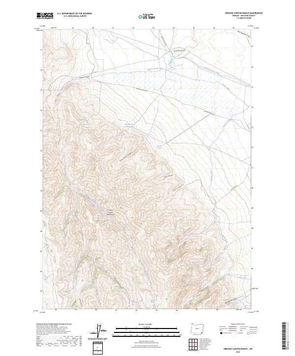
2023 Map of Oregon Canyon Ranch
USGS Topo · Published 2023About this map
The Oregon Canyon Mountains dominate this high-desert landscape in southeastern Oregon, where water management is central to the land's utility. Significant irrigation and water-gathering infrastructure is evident through features like the Echave Ditch, Segundo Ditch, and the Schoolhouse Pit Reservoir. These systems suggest a history of ranching or agricultural efforts to harness the seasonal flow of Oregon Canyon Creek and its many tributaries, including the East Fork Oregon Canyon Creek and Jaca Creek. Numerous named springs, such as Buckaroo Spring and Poplar Spring, dot the terrain, providing essential water sources in an area defined by deep canyons like Schoolhouse Canyon and Angel Canyon. The network of primitive routes, including Oregon Canyon Rd and Pole Creek Rd, follows the natural contours of the draws and ridges, connecting isolated water points and grazing lands.
Find a feature on this map
35 named features on this map. Tap any name to fly to it.
Don’t see what you’re looking for? This feature index may not catch every label — zoom into the map to look around manually.
Map Details
Editions of this 2023 Oregon Canyon Ranch Map
This is the sole edition of this map. No revisions or reprints were ever made.
Other maps of this area

1955 · Jordan Valley
USGS Topo · 1:250,000

1955 · Adel
USGS Topo · 1:250,000

1957 · Adel
USGS Topo · 1:250,000

1957 · Jordan Valley
USGS Topo · 1:250,000

1958 · Adel
USGS Topo · 1:250,000

1958 · Jordan Valley
USGS Topo · 1:250,000

1962 · Adel
USGS Topo · 1:250,000
1981 · Dry Creek Bench
USGS Topo · 1:24,000
1981 · Doolittle Creek
USGS Topo · 1:24,000
1982 · Payne Creek
USGS Topo · 1:24,000