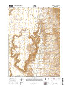
2017 Map of Oregon End Table
USGS Topo · Published 2017About this map
Oregon End Table rises above a landscape defined by an intricate network of drainages and seasonal water sources in southeastern Harney County. The area’s hydrological character is shaped by numerous named creeks, including Rincon Cr and Stonehouse Cr, which collect into the Oregon End Reservoir. The map reflects a remote pocket of the Oregon high desert where water management and topography dictate the land use. Isolated water points like Indian Spring and the rugged cuts of Rough Canyon highlight the geographic challenges faced by anyone navigating this terrain. Transport through this high-plateau environment is concentrated along several established routes, most notably Fields Denio Rd, Rincon Dr, and Oregon End Table Rd, which provide access to the various sections and range lands of this arid territory.
Find a feature on this map
20 named features on this map. Tap any name to fly to it.
Don’t see what you’re looking for? This feature index may not catch every label — zoom into the map to look around manually.
Map Details
Editions of this 2017 Oregon End Table Map
This is the sole edition of this map. No revisions or reprints were ever made.
Other maps of this area

1886 · Disaster
USGS Topo · 1:250,000

1893 · Disaster
USGS Topo · 1:250,000

1954 · Vya
USGS Topo · 1:250,000

1955 · Adel
USGS Topo · 1:250,000

1957 · Adel
USGS Topo · 1:250,000

1958 · Vya
USGS Topo · 1:250,000

1958 · Adel
USGS Topo · 1:250,000

1962 · Vya
USGS Topo · 1:250,000

1962 · Adel
USGS Topo · 1:250,000
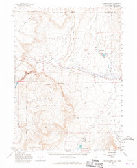
1965 · Railroad Point
USGS Topo · 1:62,500