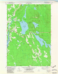
1982 Map of Orland
USGS Topo · Published 1983About this map
Alamoosook Lake and the winding Narramissic River anchor this coastal Maine landscape in the early 1980s. The region is characterized by a complex network of waterways, including the Dead River and the expansive Toddy Pond, which shapes the boundaries of Orland and Penobscot. A notable landmark is the Craig Brook National Fish Hatchery situated on the northern shore of the lake, reflecting the area's long-standing connection to local fisheries and natural resource management.
Find a feature on this map
59 named features on this map. Tap any name to fly to it.
Don’t see what you’re looking for? This feature index may not catch every label — zoom into the map to look around manually.
Map Details
Editions of this 1982 Orland Map
This is the sole edition of this map. No revisions or reprints were ever made.
Other maps of this area

1900 · Orland
USGS Topo · 1:62,500

1900 · Bucksport
USGS Topo · 1:62,500

1902 · Bucksport
USGS Topo · 1:62,500

1902 · Castine
USGS Topo · 1:62,500

1904 · Castine
USGS Topo · 1:62,500

1904 · Bluehill
USGS Topo · 1:62,500

1905 · Penobscot Bay
USGS Topo · 1:125,000

1941 · Castine
USGS Topo · 1:62,500

1942 · Orland
USGS Topo · 1:62,500

1942 · Bucksport
USGS Topo · 1:62,500