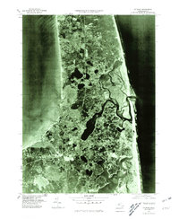
1977 Map of Orleans
USGS Topo · Published 1981About this map
Orleans and the surrounding outer cape landscape are revealed through the precise lens of late-1970s aerial photography in this orthophotograph. The intricate network of tidal marshes, salt ponds, and meandering inlets defines the area between Cape Cod Bay and the Atlantic Ocean. The imagery highlights the delicate geography of Nauset Beach, a narrow barrier of sand that shields the inland waters and settlements of Tonset and Eastham from the open sea.
Find a feature on this map
7 named features on this map. Tap any name to fly to it.
Don’t see what you’re looking for? This feature index may not catch every label — zoom into the map to look around manually.
Map Details
Editions of this 1977 Orleans Map
This is the sole edition of this map. No revisions or reprints were ever made.
Other maps of this area

1887 · Wellfleet
USGS Topo · 1:62,500

1887 · Yarmouth
USGS Topo · 1:62,500

1888 · Chatham
USGS Topo · 1:62,500

1889 · Yarmouth
USGS Topo · 1:62,500

1889 · Wellfleet
USGS Topo · 1:62,500

1893 · Chatham
USGS Topo · 1:62,500

1893 · Yarmouth
USGS Topo · 1:62,500

1893 · Wellfleet
USGS Topo · 1:62,500

1917 · Chatham
USGS Topo · 1:62,500

1942 · Cape Cod Bay
USGS Topo · 1:125,000