
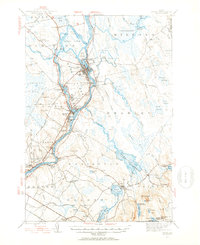
1944 Map of Orono
USGS Topo · Published 1954About this map
The Penobscot River serves as the central artery of this 1944 landscape, anchoring the industrial and educational hubs of Old Town and Orono. At the heart of the river, Indian Island and Orson Island sit adjacent to the extensive campus of the University of Maine, while the Maine Central Railroad facilitates the movement of goods through Milford and Bradley. The map captures a transition from the dense riverside settlements to the expansive wetlands of Caribou Bog and Sunkhaze Meadows further east.
Find a feature on this map
101 named features on this map. Tap any name to fly to it.
Don’t see what you’re looking for? This feature index may not catch every label — zoom into the map to look around manually.
Map Details
Editions of this 1944 Orono Map
2 editions found
Other maps of this area

1900 · Orland
USGS Topo · 1:62,500

1900 · Bucksport
USGS Topo · 1:62,500

1902 · Orono
USGS Topo · 1:62,500

1902 · Bucksport
USGS Topo · 1:62,500

1902 · Bangor
USGS Topo · 1:62,500

1911 · Ellsworth
USGS Topo · 1:62,500

1917 · Passadumkeag
USGS Topo · 1:62,500

1929 · Great Pond
USGS Topo · 1:48,000

1931 · Saponac
USGS Topo · 1:48,000

1932 · Great Pond
USGS Topo · 1:62,500