
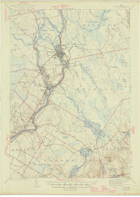
1946 Map of Orono
USGS Topo · Published 1946About this map
The Penobscot River and its western branch, the Stillwater River, define the industrial and academic core of this mid-1940s landscape. Between these waters lies Marsh Island, home to the sprawling University of Maine campus and the manufacturing centers of Old Town, Stillwater, and Great Works. The river's flow is punctuated by numerous islands like Orson Island and Boom Islands, indicating a history of timber management and river-driving commerce.
Find a feature on this map
98 named features on this map. Tap any name to fly to it.
Don’t see what you’re looking for? This feature index may not catch every label — zoom into the map to look around manually.
Map Details
Editions of this 1946 Orono Map
2 editions found
Other maps of this area

1900 · Orland
USGS Topo · 1:62,500

1900 · Bucksport
USGS Topo · 1:62,500

1902 · Orono
USGS Topo · 1:62,500

1902 · Bucksport
USGS Topo · 1:62,500

1902 · Bangor
USGS Topo · 1:62,500

1911 · Ellsworth
USGS Topo · 1:62,500

1917 · Passadumkeag
USGS Topo · 1:62,500

1929 · Great Pond
USGS Topo · 1:48,000

1931 · Saponac
USGS Topo · 1:48,000

1932 · Great Pond
USGS Topo · 1:62,500