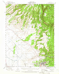
1942 Map of Oroville
USGS Topo · Published 1966About this map
The Feather River corridor and its surrounding foothills reveal a landscape shaped by hydraulic mining and railway expansion during the early 1940s. Centered on the city of Oroville, this survey illustrates a complex transition from the valley floor to the Sierra Nevada foothills, marked by significant water engineering and resource extraction. Settlements like Cherokee and Oregon City sit amidst a terrain defined by deep ravines and ridges, including Doe Mill Ridge and McKay Ridge. The industrial legacy of the region is evident in the New Era Mine and Bumble Bee Mines, while the irrigation network of the Western Canal supports the agricultural lands of Esquon and Fernandez. This period shows the coexistence of established rail routes, such as the Southern Pacific and Sacramento Northern, with emerging mountain roads like the Oroville Highway and Southern Pacific Highway.
Find a feature on this map
90 named features on this map. Tap any name to fly to it.
Don’t see what you’re looking for? This feature index may not catch every label — zoom into the map to look around manually.
Map Details
Editions of this 1942 Oroville Map
2 editions found

Other maps of this area

1888 · Marysville
USGS Topo · 1:125,000

1888 · Smartsville
USGS Topo · 1:125,000

1888 · Bidwell Bar
USGS Topo · 1:125,000

1891 · Bidwell Bar
USGS Topo · 1:125,000

1891 · Chico
USGS Topo · 1:125,000

1891 · Marysville
USGS Topo · 1:125,000

1891 · Smartsville
USGS Topo · 1:125,000

1892 · Smartsville
USGS Topo · 1:125,000

1893 · Chico
USGS Topo · 1:125,000

1893 · Bidwell Bar
USGS Topo · 1:125,000