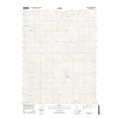
2015 Map of Orrs Springs
USGS Topo · Published 2015About this map
Orrs Springs serves as the central landmark in this portion of Mendocino County, where the hydrology of Northern California's coastal ranges is on full display. The area acts as a significant drainage divide, with the headwaters of the S Fork Big River flowing toward the northwest while the S Br N Fork Navarro River and its numerous tributaries, such as Soda Cr and Daugherty Cr, carve out the southern landscape. The terrain is defined by prominent elevations including Eagle Rock, Pine Ridge, and Alaska Ridge, which dictate the winding paths of rural routes like Masonite Rd and the aptly named Find Yer Way. This network of creeks—including Ackerman Cr, York Cr, and Hensley Cr—illustrates a deeply dissected topography where historical movement was largely governed by the steep ridges and narrow canyon floors.
Find a feature on this map
29 named features on this map. Tap any name to fly to it.
Don’t see what you’re looking for? This feature index may not catch every label — zoom into the map to look around manually.
Map Details
Editions of this 2015 Orrs Springs Map
This is the sole edition of this map. No revisions or reprints were ever made.
Other maps of this area
1920 · Ukiah
USGS Topo · 1:62,500
1922 · Willits
USGS Topo · 1:62,500
1942 · Willits
USGS Topo · 1:62,500
1943 · Pomo
USGS Topo · 1:62,500
1943 · Boonville
USGS Topo · 1:62,500
1944 · Ukiah
USGS Topo · 1:62,500
1944 · Willits
USGS Topo · 1:62,500
1957 · Ukiah
USGS Topo · 1:250,000
1958 · Ukiah
USGS Topo · 1:24,000
1958 · Elledge Peak
USGS Topo · 1:24,000