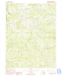
1991 Map of Orrs Springs
USGS Topo · Published 1991About this map
Orrs Springs serves as a central landmark in this rugged portion of the California Coast Ranges, where the headwaters of several major drainage systems diverge. The landscape is defined by its deep canyons and prominent ridges, such as Pine Ridge and Alaska Ridge, which separate the waters of the South Fork Big River from the South Branch North Fork Navarro River. This 1991 provisional survey captures a network of private holdings and remote outposts, including Greenfield Ranch, Mann Ranch, and Eagle Rock Ranch. The presence of the Montgomery Woods State Reserve in the northwest corner highlights the region's botanical significance, protecting ancient groves amidst the commercial ranching and timber geography. Numerous creeks, such as Ackerman Creek and Daugherty Creek, carve through the terrain, illustrating the intricate hydrology that has shaped Mendocino County’s development and natural history.
Find a feature on this map
23 named features on this map. Tap any name to fly to it.
Don’t see what you’re looking for? This feature index may not catch every label — zoom into the map to look around manually.
Map Details
Editions of this 1991 Orrs Springs Map
This is the sole edition of this map. No revisions or reprints were ever made.
Other maps of this area

1920 · Ukiah
USGS Topo · 1:62,500

1922 · Willits
USGS Topo · 1:62,500

1942 · Willits
USGS Topo · 1:62,500

1943 · Pomo
USGS Topo · 1:62,500

1943 · Boonville
USGS Topo · 1:62,500

1944 · Ukiah
USGS Topo · 1:62,500

1944 · Willits
USGS Topo · 1:62,500

1957 · Ukiah
USGS Topo · 1:250,000

1958 · Ukiah
USGS Topo · 1:24,000
1958 · Elledge Peak
USGS Topo · 1:24,000