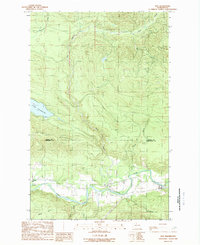
1989 Map of Oso
USGS Topo · Published 1989About this map
The North Fork Stillaguamish River snakes through the valley at the foot of Frailey Mountain, defining the settlement patterns of late 20th-century Snohomish County. Small communities like Oso and Cicero are centered along the river and State Route 530, while the northern portion of the map is dominated by the steep slopes of the Skagit Co Snohomish Co border.
Find a feature on this map
22 named features on this map. Tap any name to fly to it.
Don’t see what you’re looking for? This feature index may not catch every label — zoom into the map to look around manually.
Map Details
Editions of this 1989 Oso Map
This is the sole edition of this map. No revisions or reprints were ever made.
Other maps of this area

1899 · Stillaguamish
USGS Topo · 1:125,000

1901 · Stilaguamish
USGS Topo · 1:125,000

1911 · Mount Vernon
USGS Topo · 1:125,000

1941 · Marysville
USGS Topo · 1:62,500

1943 · Marysville
USGS Topo · 1:62,500

1944 · Clear Lake
USGS Topo · 1:62,500

1955 · Concrete
USGS Topo · 1:250,000
1956 · Arlington East
USGS Topo · 1:24,000
1956 · Clear Lake
USGS Topo · 1:62,500
1956 · Oso
USGS Topo · 1:62,500