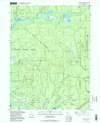
1997 Map of Oswego Lake
USGS Topo · Published 1998About this map
The Pine Barrens of Burlington and Ocean Counties are meticulously detailed here, showing a landscape dominated by extensive conservation areas. Dense networks of state land including Wharton State Forest, Bass River State Forest, and Penn State Forest converge, preserving a wilderness of cedar swamps and sandy plains. Waterways like the Oswego River and Wading River dictate the geography, punctuated by local landmarks such as Sim Place and the historic crossroads near Leektown.
Find a feature on this map
70 named features on this map. Tap any name to fly to it.
Don’t see what you’re looking for? This feature index may not catch every label — zoom into the map to look around manually.
Map Details
Editions of this 1997 Oswego Lake Map
This is the sole edition of this map. No revisions or reprints were ever made.
Other maps of this area

1884 · Whitings
USGS Topo · 1:62,500

1888 · Pemberton
USGS Topo · 1:62,500

1888 · Little Egg Harbor
USGS Topo · 1:62,500

1888 · Whitings
USGS Topo · 1:62,500

1890 · Mullica
USGS Topo · 1:62,500

1893 · Little Egg Harbor
USGS Topo · 1:62,500

1894 · Pemberton
USGS Topo · 1:62,500

1894 · Mullica
USGS Topo · 1:62,500

1898 · Pemberton
USGS Topo · 1:62,500

1898 · Mullica
USGS Topo · 1:62,500
Featured Places
- Stafford Township, NJ
- Little Egg Harbor Township, NJ
- Bass River Township, NJ
- Washington Township, NJ
- Sim Place, Bass River Township