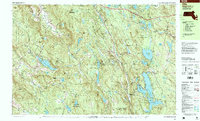
1997 Map of Otis
USGS Topo · Published 1999About this map
The town of Otis and its surrounding woodlands define this Berkshire County landscape as it appeared in the late 1990s. This territory is characterized by a dense network of state-managed lands, including Beartown State Forest, Otis State Forest, and Sandisfield State Forest. The Appalachian Trail winds through the western ridges near Tyringham and Monterey, tracing a path above the waters of Lake Garfield and Brewer Lake. These highlands separate the drainage of Crystal Brook and the Clam River, illustrating the rugged topography that has historically shaped settlement in this region.
Find a feature on this map
112 named features on this map. Tap any name to fly to it.
Don’t see what you’re looking for? This feature index may not catch every label — zoom into the map to look around manually.
Map Details
Editions of this 1997 Otis Map
This is the sole edition of this map. No revisions or reprints were ever made.
Other maps of this area

1885 · Sheffield
USGS Topo · 1:62,500

1886 · Chesterfield
USGS Topo · 1:62,500

1886 · Becket
USGS Topo · 1:62,500

1887 · Granville
USGS Topo · 1:62,500

1888 · Sheffield
USGS Topo · 1:62,500

1888 · Becket
USGS Topo · 1:62,500

1888 · Sandisfield
USGS Topo · 1:62,500

1888 · Chesterfield
USGS Topo · 1:62,500

1888 · Pittsfield
USGS Topo · 1:62,500

1889 · Granville
USGS Topo · 1:62,500