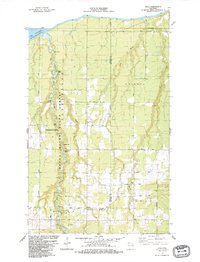
1984 Map of Oulu
USGS Topo · Published 1984About this map
The Bois Brule River snakes through the western portion of this Northern Wisconsin landscape, its course marked by features such as Weir Riffles, Long Riffles, and the cascading Shale Falls. This mid-1980s data highlights the Brule River State Forest, a significant conservation area managed for waterfowl. To the east, the rural communities of Oulu and Waino are defined by a network of local roads such as Pudas Road and Koski Road, reflecting a pattern of mid-century agricultural and residential development in Douglas and Bayfield Counties. Genealogists will find a high density of burial grounds including Rest Haven Cem, Oulu Cem, and Hillcrest Cem, while the northern coastline meets Lake Superior at Brule Point. The presence of several Gravel Pits and various rapids like the Highway 13 Rapids underscore the area's geology and its relationship to the drainage basin flowing into the Great Lakes.
Find a feature on this map
43 named features on this map. Tap any name to fly to it.
Don’t see what you’re looking for? This feature index may not catch every label — zoom into the map to look around manually.
Map Details
Editions of this 1984 Oulu Map
This is the sole edition of this map. No revisions or reprints were ever made.
Other maps of this area

1943 · Port Wing
USGS Topo · 1:48,000

1943 · Iron Lake
USGS Topo · 1:48,000

1946 · Port Wing
USGS Topo · 1:48,000

1947 · Brule
USGS Topo · 1:48,000

1947 · Iron Lake
USGS Topo · 1:48,000

1953 · Ashland
USGS Topo · 1:250,000

1954 · Lake Nebagamon
USGS Topo · 1:24,000

1954 · Cloverland
USGS Topo · 1:24,000

1958 · Ashland
USGS Topo · 1:250,000

1961 · Iron Lake SW
USGS Topo · 1:24,000